Remember, having a storm system moving through means there's a battle in the atmosphere. Depending on timing, you can get chilly temperatures for a day or two behind the system. So while the week as a whole will average well above in terms of temperatures, it would not be out of the question to have a day or two of cold weather. Could that be Christmas Eve or Christmas Day? Again too early, but I'm looking everywhere for anything. LOL
__________________________________________________________________________
Ok, let's hope it doesn't get to that point. We're talking about a forecast more than a week away, but we have a high degree of confidence temperatures will be well above average in the days leading up to Christmas this year.
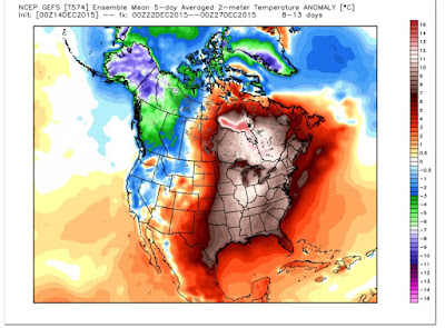
While we will get a few days of typical December cold this week, we should go right back to the ridge over the central and eastern United States and a trough over the west. Ski lovers out there are enjoying this for sure!
In the video I posted Sunday, I talked about the Arctic Oscillation (AO). In its positive phase, it usually leads to above average temperatures and in its negative, below average temperatures. The negative supports a suppressed jet stream allowing colder air to move into our region. There are exceptions to this rule, but the AO is a great tool to use when forecasting 1-2 weeks out. For example, at times last winter, the AO was strongly positive, but we kept getting pushes of cold air. This had to do with a ridge building into Alaska dislodging the cold air and sending it south. However, this does not appear to be the case next week.
The one thing I have concern over is a storm system both of the main computer models are hinting at. The Euro and the GFS both show concern around Christmas Eve and maybe Christmas Day for rain. With mild air in place, you have to wonder about severe weather too. I'M NOT SAYING THAT IS OUR FORECAST AT THIS TIME. The only aspect to the forecast we're confident about are mild temperatures. Specifics this far out are very tough to forecast.
Remember, we're also under the influence of an El Nino. Let's go back to December 1982. That was an El Nino winter and we had a swarm of tornadoes on Christmas Eve. AGAIN, I'M NOT FORECASTING THAT AT THIS TIME, but it's always in the back of my mind. No El Nino year is exactly alike! That's another important thing to remember.
 |
| The GFS also shows the trough west and ridge east.... MILD |


No comments:
Post a Comment